By Mimi Mato, Tuesday, July 10, 2012, 12:48 pm for the original French version.
English fixed by Pimprenelle Xwzq, Sol hog, and Marguerite Dehler.
|
Introduction A - From a distance B - A Closer Look C- From very close (vertical streams) D- Of Gods ... and Devils TABLE OF CONTENT |
The first sphere was, immobile at our time and size scales, though we saw it move, at a very slow pace, a few centimeters per year while turning on itself up to about 1600 km/h at the farthest from its rotation axis, and, with or without the sun's reflection, left it totally indifferent except for the thin film laying a few centimeters on its surface.
The second sphere, of lower density, water, was incomparably more mobile: passing from streams of a few centimeters per year to those easily reaching 10 km/h even reaching peaks of 20 km/h. The comparison is huge. Another important detail: If the Earth takes its heat from within it, the heat generated by the hellish pressures that the law of gravity imposes on its material at the center, waters, then, heat up under the sun at its upper surface. A situation perfectly reversed from this point of view, the bottom remaining around +4°C year round, and the surface reaching as high as +35°C "at worst" on some places, to zero in the colder zones, but without being able to maintain temperatures at a great expanse for long.
Ici, nous allons changer d'échelle en densité (donc plus de vitesse et moins d'inertie) : Plus on monte et moins il y a de gaz, jusqu'à atteindre le vide intersidéral mais les choses ne sont pas aussi simples.
Our planet, like other celestial objects, is formed from its center, material settling in layers. Each layer consists mainly of elements with the same density: at the far center, the core of the Earth is primarily composed of nickel and iron. The surrounding magma is composed of lighter oxides of silica, aluminum, magnesium and lighter calcium. Its crust is made of oxides of silica and magnesium (oceanic plates) or silica and aluminum (continental), then there is the water layer (hydrogen and oxygen). Then the nitrogen layer with mainly oxygen (one third of the air, roughly) and some other far rarer gasses, among which is the famous Ozone (made with three atoms of oxygen). This is layered by densities until the Earth gravity has no influence on what floats in the void.
By the way, you can see that oxygen is everywhere, from far above our heads to far below our feet (oxide = oxygen + something else).
This sedimentation is visible:
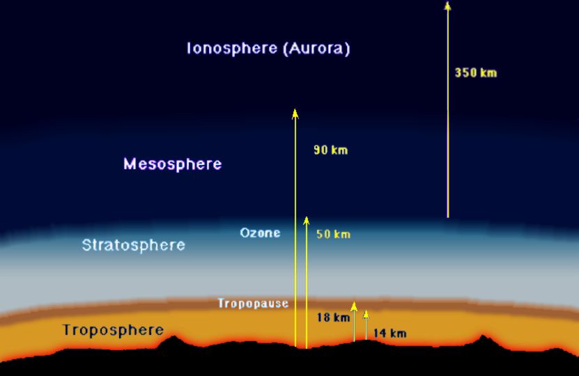
It ideally depicts the atmosphere's layering:
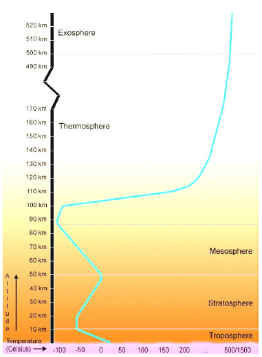
Things are a little more complex on the temperature's issue because of constraints occurring with altitude, i.e., atmospheric density and composition:
At the bottom, the first atmospheric layer is called the Troposphere and it cools with altitude at a rate of about 0.7 °C per 100 m (0.644 °C to be a bit more precise) . The temperature lowering will drop to below -50°C at about 15,000 m (NB: Everest = 8,488 m), this is the end of the Troposphere. Then it will stabilize for a time.
This layer, where the temperature is approximately of -50°C for several kilometers (variable thickness, but always less than seven miles or 10km), is called the Tropopause. It also varies in altitude, in fact, according to seasons and latitudes, 8,000 m from poles to 18,000 at the Equator with an average of 11,000. In addition, it expands more in altitude during summertime than in winter, and we will come back to that later.
Above the Tropopause is the Stratosphere, where temperatures begins to increase with altitude, reaching close to the zero mark, at around 50 km.
Why this strange behaviour of temperature between 0 and 50 km of altitude?
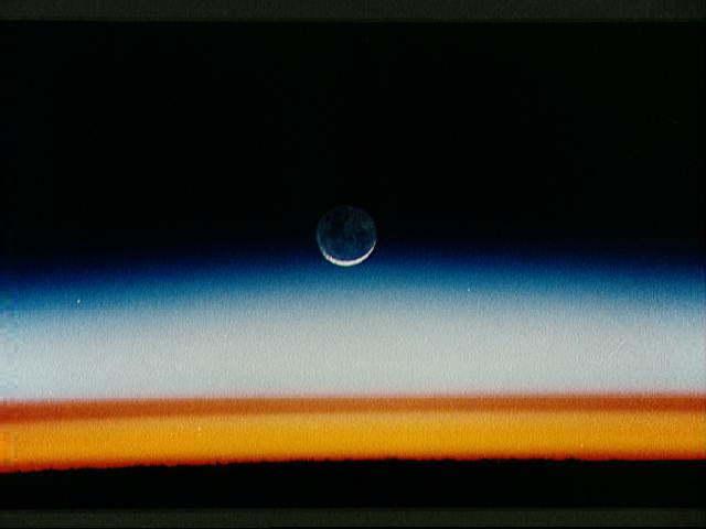
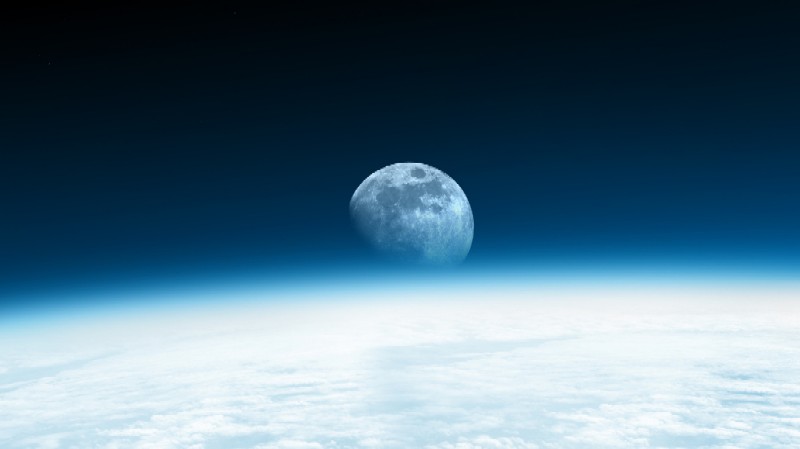
Why this such layering of atmospheric colours as seen from the space shuttle?
The main answer is "the Ozone layer" :
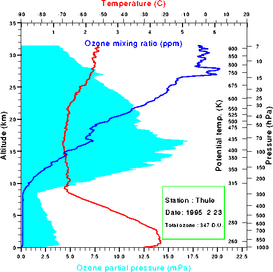
It is distributed in the first three layers: It starts in the Troposphere, at about 10,000 m - from it the known impact of planes on it - to end at the end of the Stratosphere, by about 50 km of altitude. Therefore it is about 40 km thick. That said, most of the Ozone is in the Tropopause, roughly a little more than the half. In addition, if all the Ozone layer was brought to our density and pressure at the ground level, it would be 3 mm thick. So clearly there is "not that much". In addition, because of solar radiation winds, gases are altered, which naturally the Ozone regenerates itself, but slowly.
As you probably know, the Ozone reflects much of the sun's rays back through space and absorbs most of the ultraviolet rays, making Life possible on Earth even though it is physiologically toxic for us: Without the Ozone layer, the soil would be permanently and deeply burnt-toasted, on land as at sea (reminder: The UVs are more penetrating than the light that they "overflow." Their high energy breaks all complex molecules, particularly the DNA).
If the rays' reflection has no other significant effect than allowing colourful pictures be taken from the space shuttle (the rays' refraction by the Ozone induces this photogenic luminosity of the stratosphere and of the two other layers, at dawn and dusk), the rays'absorption corresponds to a friction, to a transformation, an energy transfer. No matter where in the Universe, absorbing energy implies an increase of molecular agitation, which is the exact definition of heat. The bulk of the UV radiation -- the "hardest" rays, the most energizing -- is absorbed by the Ozone. The Ozone layer is thus a spatial heating shield composed mainly of the thin Tropopause, figuratively, the protective cover of Life on the Earth's Aquarium.
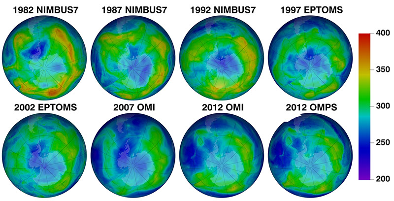
Evolution of the "hole" in the Ozone layer since 1982. We see that it grows steadily.
** link no longer available: ** Read (French):The hole in the Ozone layer: Presentation .
Daily monitoring: OzoneWatch-NASA
In summary, the temperature rises gradually throughout all the Ozone, from about -50 °C at the Troposphere's end, and close to zero at the end of the Stratosphere. The different refraction of the three layers is due to their differences in Ozone concentration among each other, forming these different colours.
Without the Ozone, the temperature would continue to uniformly decrease with altitude and there would be almost no refraction, no pretty pictures, nor life on Earth either. All radiation, with all its force, would crash to the ground and oceans, thereby prohibiting the occurrence of any complex molecule. In addition, the water vapor ascent would not be stopped by the Tropopause and global climatology would be radically different.
Above all that, at some 50 km high, we are entering the Mesosphere where there is virtually no Ozone. It is not the void yet, there are gasses even if nothing absorbs the solar energy, which, thus crosses it "straight through". Therefore the temperature decreases to reach a new low record of the atmosphere at its upper limit: -100 °C at about 90 km of altitude. The Mesosphere is still the first shield for Life. This is the layer where meteors (more than 40 tones per day, on average) decay, by friction in these gases (nitrogen, oxygen, carbon dioxide mainly, then a tad of residual Ozone and a hint of rare gasses, a bit like "down below" but far less dense).
The last layer is the Thermosphere, the seat of Northern Lights. The sunrays' bombardment is so intense that all gasses are ionized into a "magma" of ions. Ionization is the disintegration of molecules in the sense that each atom disengages from the others: becomes an ion. This is something that involves an intense release of heat. So, the temperature sharply rises with altitude while the void steps up and this until it becomes too intense to measure anything, that is to say, quite arbitrarily, by 500 km above the ground and with a temperature of around +1,500°C.
Then it is the Exosphere, we are no longer on Earth.
The temperature curve through the atmosphere and according to altitude, is, therefore and basically, like this:
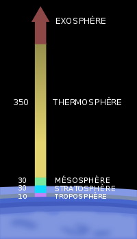
The Météo-France educational page (in French) will give you other interesting details, but I really wanted to point that if the center of the Earth is about 6,370 km below our feet, above our heads all is over at only 15~20 km and what happens onwards to the 340 following kilometers, while essentially empty, protects us from the worst extremes.
Our aquarium is indeed very very thin:
Now, let us go back down a little in these fifteen kilometers since it is there everything happens:
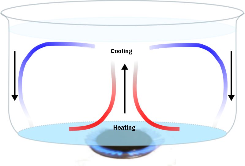
Although considerably more dense than anything that overhangs up til the interstellar space, this thin varnish layer of gasses is not static, all the less so in that it is heated by its base, a bit like liquid on a fire.
It's as if we were living in the few millimeters of the water lining the bottom of a pan horizontally rotating on itself and in contact with an immobile off-centre fire, touching the bottom edge only, like a torch directed at the side and underneath, a bit like this, but with less water (here, the water represents the Tropopause air and its height is exaggerated. The whole portrays only one hemisphere, the equator being the bottom of the pan):
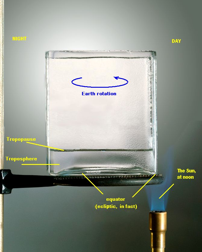
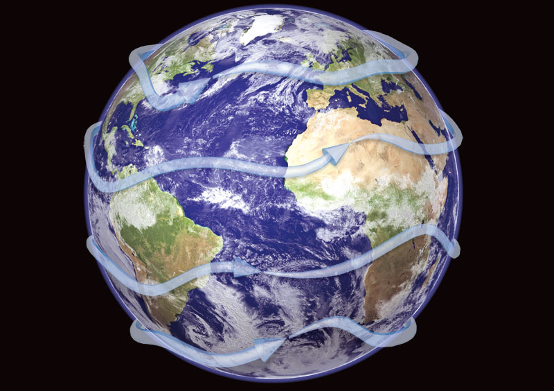
The Earth being more or less round, we thus have a sort of "spherical pan" turning on itself in the void, and in front of the sun. Its rotation induces the movement of the waters which covers its two-thirds, and of the air closest to its surface, the one which is trapped by gravity under the Tropopause layer. As the centrifugal force is the same everywhere, the fastest speed located at the farthest point from the rotation axis, at the equator, and is gradually reduces the closer we get to the axis, at the poles.
The air is cold at the poles because, always being tangent, the Sun irradiates less per cm². In addition and as for water, the cold air being heavier and denser than the warm one, it pushes warm air back toward the equator.
One might expect North-South winds - and this would be the case if the Earth was not rotating - but the Earth rotation attracts them, deviate their stream from the equator to a pole or the other and they drift towards the West, are moving "slanted" or directly due west (the Trade Winds) in an apparent direction opposite to the rotation (which rotates TOWARD the East). The Earth's crust carries them by their base, faster than their upper part. This lateral driving force owed to the Earth rotation is called the Coriolis force (the name of the person who discovered it).
The Sun heats the Earth mainly at the equator (from one tropic to the other varying with the seasons). Then the land (or the sea) heats the air "from below", with which it is in contact, and expands it, thus the air becomes lighter than the surrounding one, especially that above which has no contact with the heating surface - liquid or solid - thus not heated.
Therefore a hot bubble takes shape, rounds off and then begins to rise, and goes up as long as it is warmer than its surroundings, while another begins to form below, a bit like columns of bubbles in a glass of sparkling water. The one which begins to rise cools gradually as it has lost direct contact with the "hot surface" and continues to move in air colder than it. It will stabilize and disintegrate when temperatures balance each other, at worst against the Tropopause.
At this point, this cooled air will try to go down under the hotter 'bubble' -- lighter by having just left the "hot plate" -- and gets pushed up from below. The cold air pushed from below will search to go down "as close as possible from there" until it reaches an equilibrium, or, otherwise, eventually, back to the ground where it will heat again.
At the equator, the Sun thus generates a great vertical riser hood which, once "up", splits in half against the warm Tropopause Ozone layer, some going North, the other South, symmetrically, and even more easily than the centrifugal force created by the Earth's rotation helps this climb. As we've seen, while rising to the Tropopause all this cools by 0.7° C per 100m as long as the Ozone does not stabilize its temperature, at the Tropopause. As cold air can't rise above hot air due to its weight, the Tropopause is a cover, an "impassable" barrier which pushes cold air beneath it, though occasionally can be raised by it, but not by much and not for long.
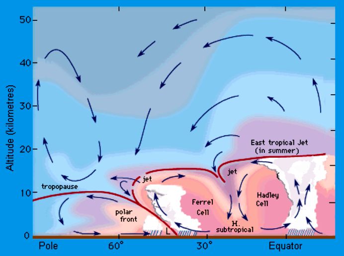
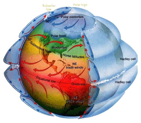
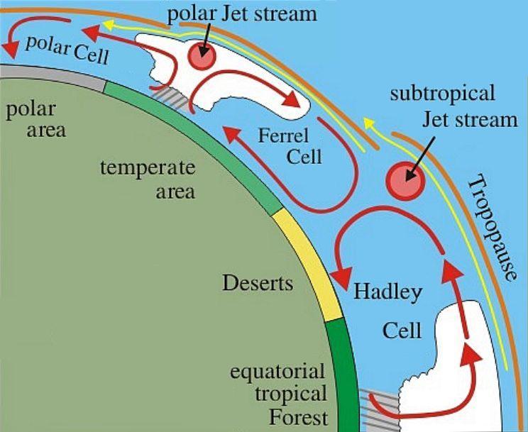
Then this air, cooled to -50 °C and prodded up by the hotter air which followed it in its climb, slips under the Tropopause seeking to fall back "further" and "as soon as possible", where it will only become possible at "dry" tropical climates. From there it forms two enormous more or less permanent, deformed rolls around the whole Earth and on both sides of the equator into streams directed equator-pole with a westward drift imposed by Coriolis, the Earth rotation. Here we have what is called convection cells, two of them, and gigantic: known as the two Hadley cells, North and South, constituting the largest and thickest part of the Troposphere.
>> Why "fall back "further" and "as soon as possible" are located in the dry tropical climate areas?
For two reasons:
>> Why "dry" tropical?
This creates, still on each side of the equator, on the falling edge of the Hadley cell and going up towards the pole (North or South) to meet the polar air which will raise it all; another convection cell having the same gigantic roller dynamics: altitude descent on the tropics, going towards the pole on ground, then abruptly stopped against the polar air which pushes it to higher altitudes (giving rise to the well known instabilities in temperate regions), and finally, at the top, back to the tropics but this time with a deviation toward the East (the infamous "West Winds": coming from West going East), this to compensate the intense symmetrical imbalance of the monstrous Hadley rolls. These two convective rolls are named the Ferrel cells..
More poleward, there remains only the polar air in a much quieter cap, in part because of its density due to cold - the Sun's rays are too tangential to heat all that - and also because we are so much closer to the rotation axis - thus the speed of the terrestrial crust, the centrifugal and Coriolis forces are much weaker. This mass of cold air is inert in comparison to the other two. It also acts as a roll headed West, but longer retains qualities in terms of energies and forces.
All this also helps to understand that the Tropopause, the surface of the Troposphere, the Ozone shield, the ceiling, the lid, does not have the same altitude everywhere, and these variations in altitude can be substantial depending on uplifts: from 8 km at the poles, it passes over 12 at the tropics and between 15 and 20 at the equatorial level:
and, in 3 dimensions, roughly:
NB : This is a hugely exaggerated schema to ease reading, the Troposphere thickness is and remains ALWAYS under 20 km at most, it only is and remains a light varnish coat above the Earth crust. Under a single Hadley cell, on ground and towards poles, there are more than 4,000 km for, roughly, 10 in thickness in average.
In summary, to understand the general mobility of the air in our aquarium, we must imagine this ball that spins, in 24 hours, around its axis, dragging along by its movement the thin layer of air which surrounds it, the whole being floating in the void in front of a super-bright spot + torch. This way, one can imagine the solar noon rays' cone causing an expansion peak, peak moving like a wave along the cells, where the wave's stretch at its lowest on the other side of the Earth relative to its maximum, "by the end of the night".
There still remains a very important general phenomenon to consider: Jet Streams..
The previous figure, although simplistic as any theory by image is, demonstrates the "step" phenomenon which occurs at the cells borders: there is a sudden altitude fall in the Tropopause when the warm front meets the cold front of the most polar cell (as if the hot air was trying to overflow above the cold one, before being engulfed downward).
In both cases, the most equatorial cell overhangs the most polar one and this overhanging stops abruptly. Hot air strikes against a "wall" in front of which it has no other choice but to go along, either down vertically, or longitudinally following it, or turning back: It can not go climb above since it is colder than the Tropopause which covers it (and that's such a good thing!).
They are thus located on the most polar side of the Ferrel and Hadley cells, at the top, against the Tropopause and they follow the changing contours of the cells limitations. They all go eastward in general, but it also happens that, after a descent of a more polar air towards the equator or an upwelling of warmer air poleward, they are shifted very much differently, even perpendicularly. It is the fronts between the cells which decide their general direction and these fronts are very unstable, changing easily.
Useless to say that, given their altitude, these are strong streams of very cold air compared to the ground (i.e., -50 °C).
They behave much like tubes of different diameters nested into each other, the smallest being the fastest winds ( often > 300 km/h ):

They are never thick (several kilometers in height), but they can spread their horizontal margins on several hundreds of kilometers. They tend to go all around the Earth:
They are very unstable, can radically change in place and direction, sometimes in less than 24 hours, according to the cells "changing will" that they tag along with.
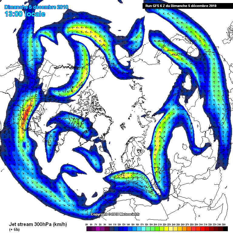
December 5, 2010.
Note the situation with respect to Greenland and compare it with the next.
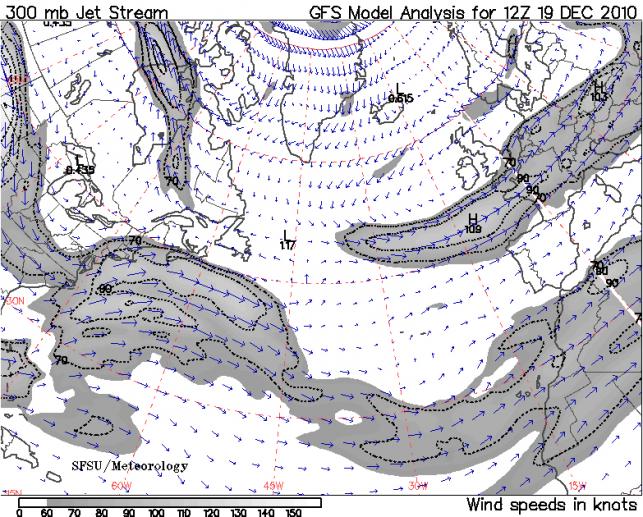
December 19, 2010, two weeks later.
They have a major influence on what happens under them: Such an air stream creates drafts and counter-streams around it. As they are limited by the Tropopause, the lift they create by literally tearing the air which reached them have astronomical consequences on the slightest disturbance they fly over, and these disturbances whose source is rooted to the ground. They are amplifiers of vertical streams, to be closely watched.
Small note that will be used further below: The circumference of the Earth at the 50th parallel is approximately of 26,000 km. Assuming that the Jet Stream remains at its average level (which is often the case) and that the average speed is only about 200 km/h, then it sweeps over the full circle in almost 5 days and a half, the full circle ...
All which comes before is a bit beyond us (by about 15 km, even ... :)) and what we feel at our level is much softer (for now) than that which makes us our sky.
At the ground level, we know mainly wind, rain, heat and drought. We know that fine weather and drought are mainly located in what we call anticyclones, that rain and wind are in and around depressions, and that these things do not stay exceptionally long at the same place. That all drifts in the air above us, following the main wind of the moment, and changes in seasons.
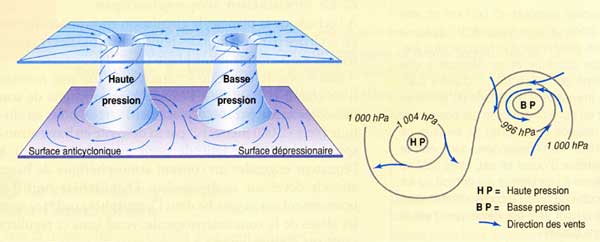
At the global level, we can still define areas preferentially anticyclonic (not only the Azores, Bermuda) or of low pressure (such as Asia Monsoons, for example):
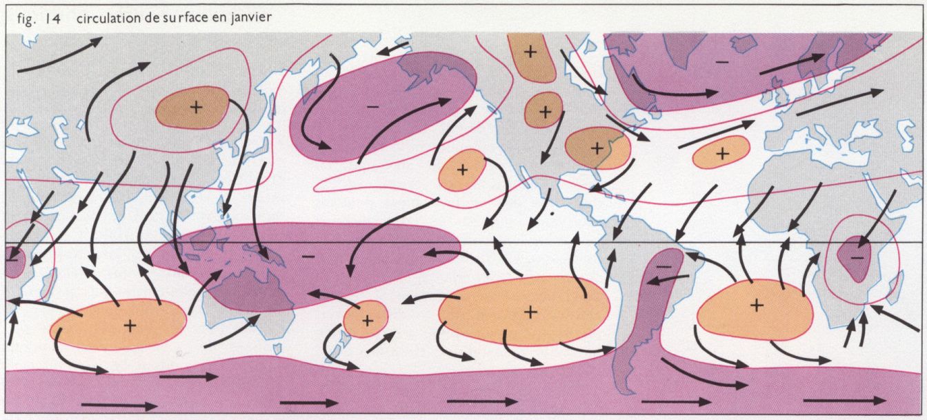
But at the local level, depression and an anticyclone, what is it?
As we saw earlier, depression is an almost vertical ascent of warm air and an anticyclone is a vertical descent of cold air, both induced by land/sea temperatures whose thermal inertia is incomparably greater than that of the air. So there is a natural tendency for windy systems to take shape between depressions and anticyclones, more or less in "mini-convective cells" patterns:
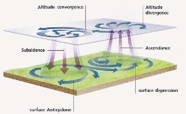
In addition, due to Coriolis, all these vertical movements are swirling. The induced shifting we saw horizontally on the ground is valid at all altitudes, and, as in these less extensive cases the "as soon as possible" is very closely available, just above for the depressions, just below for the anticyclones, the ascending or descending vortex is immediate:
The large Hadley, Ferrel and Polar cells are a bit like the largest convective of the juxtaposed and nested matriochkas that are, for the lower levels, anticyclones, depressions, cyclones, tornadoes, waterspouts, thunderstorms, clouds.
This aerial convective movement implies that the air which is falling tries to swallow the heat it meets, while the rising one is trying to get rid of its own.
The main way to play with the heat is water: An energy of one Joule changes by 1° the temperature of a liter of dry air, and the need is of around 4,185,500 Joules to do the same with 1 liter of water (it changes slightly depending on the pressure). Therefore, water absorbs or releases incomparably more heat than dry air.
Water is therefore used as the main "thermal flywheel" in the air: Its condensation forms clouds and rain, and mainly gets rids the air of its heat. Its evaporation has the opposite effect, it allows the air to heat faster. Clouds form only where an air already wet cools, in ascending currents, thus in depressions. Conversely, high pressure anticyclones are sponges and absorb all the humidity they can (which does not prevent them from having clouds in places where a mini-depression can take shape, a bubble of warmer air).
We know precisely how to calculate the altitude at which clouds form:
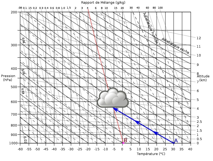
(cf, condensation by convection levels) (in French))
We also rank clouds according to their shape, altitude and size:
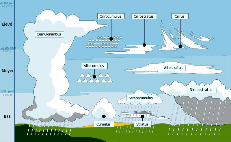
Clouds provide valuable information on the status of the air which produce them because their appearance is enough to specify in which system they evolve and at what level:
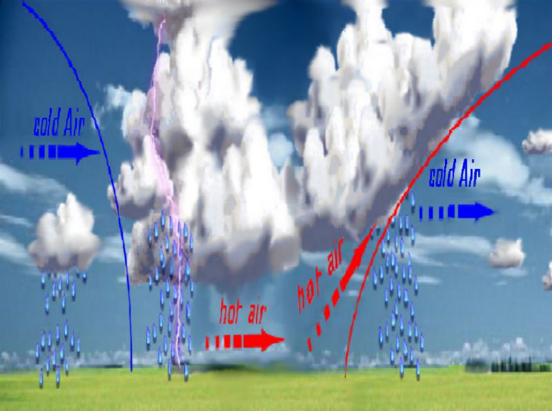
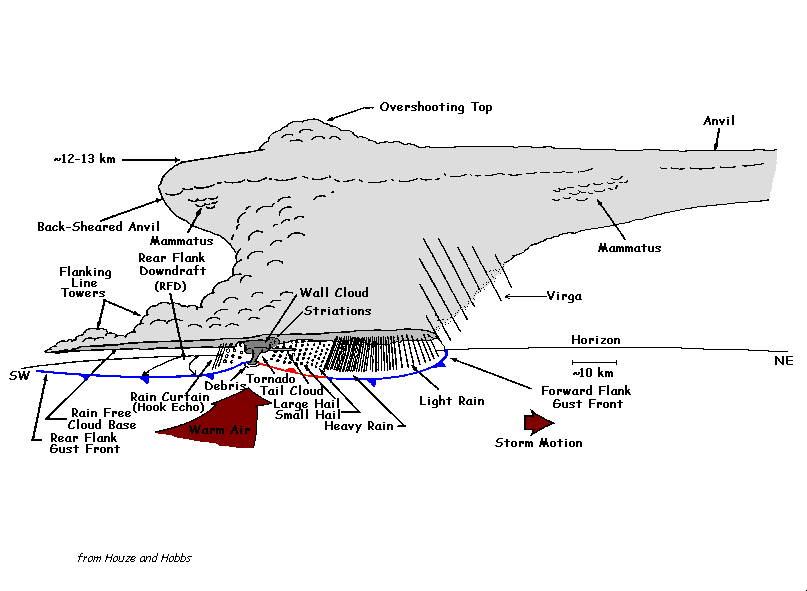
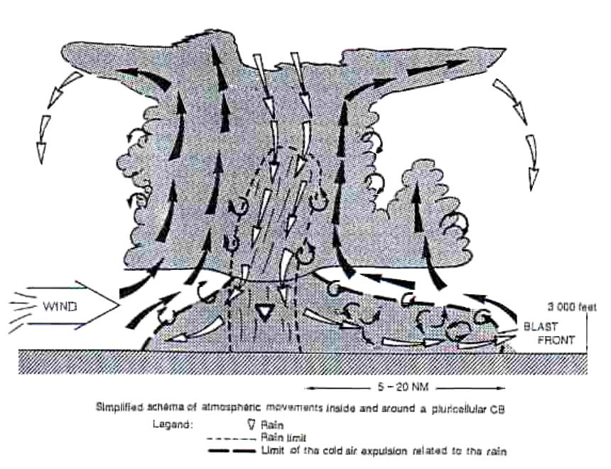
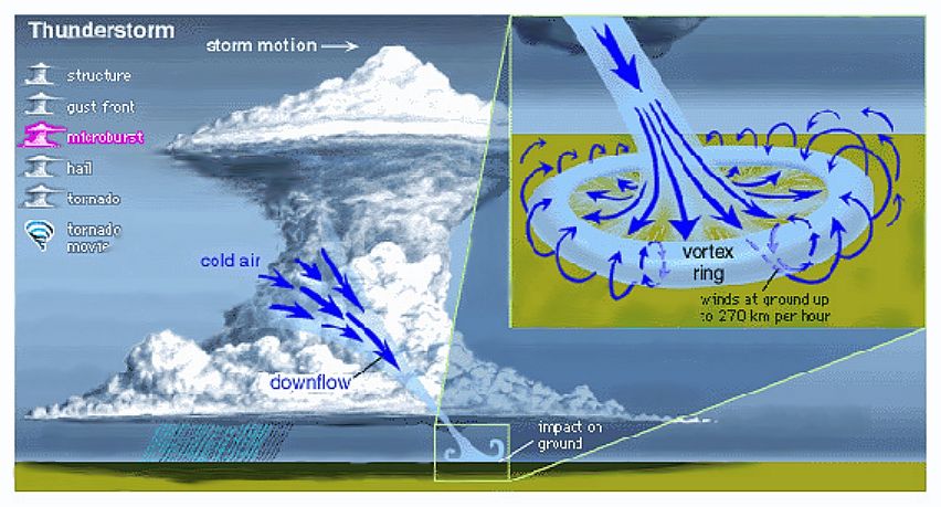
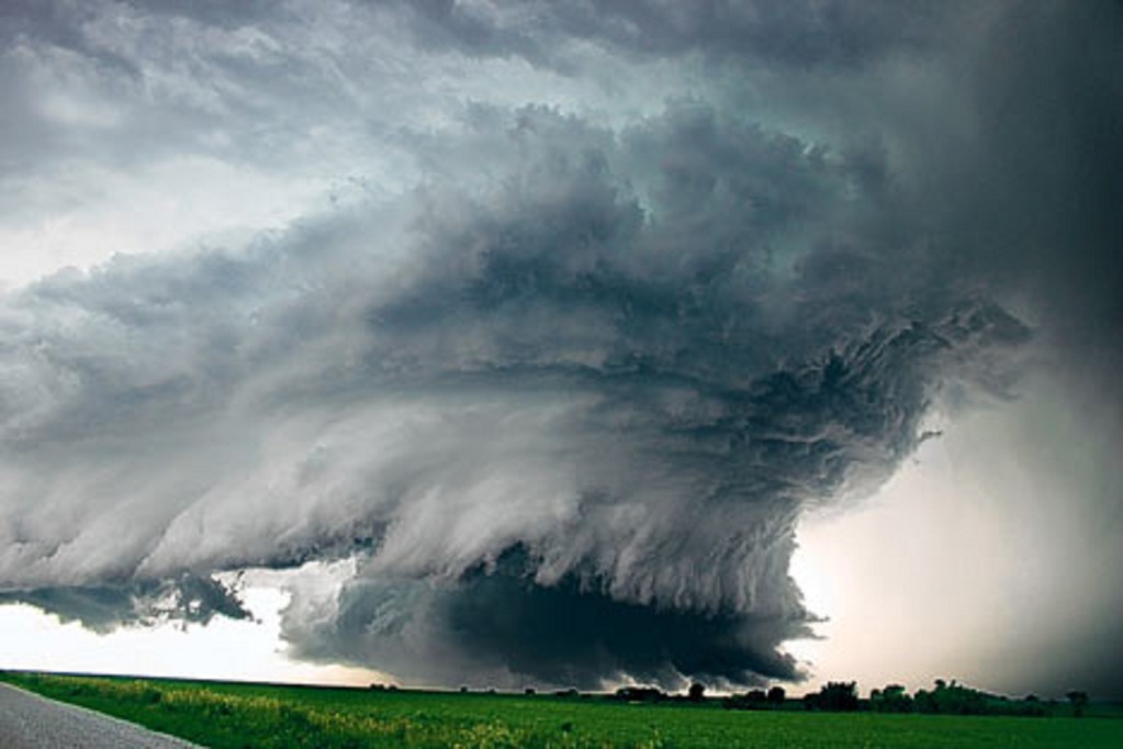
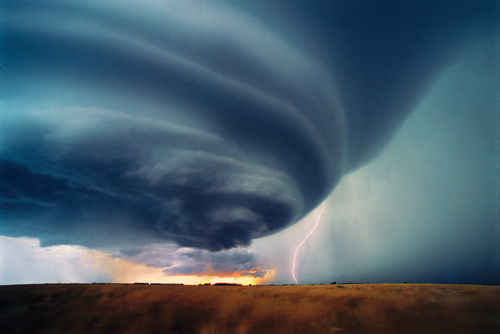
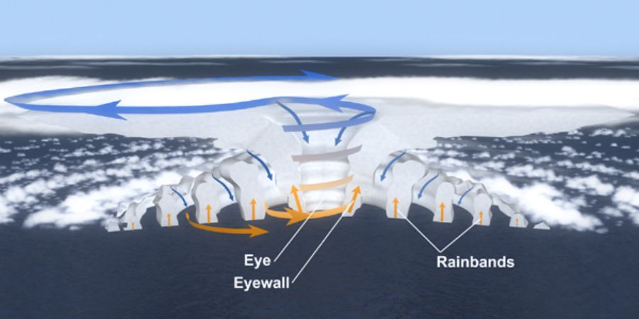
The most watched are obviously the tallest and largest ones as they follow the track of streams rising up to the Tropopause, thus those of a tremendous power. These large clouds of high speed currents are named cumulonimbus. They are articulated in and around major ascending streams which also generate strong descending counter-currents on their sides, sometimes with speeds as strong as the one of Jet Streams:
(Virga = the rain which never reaches the ground)
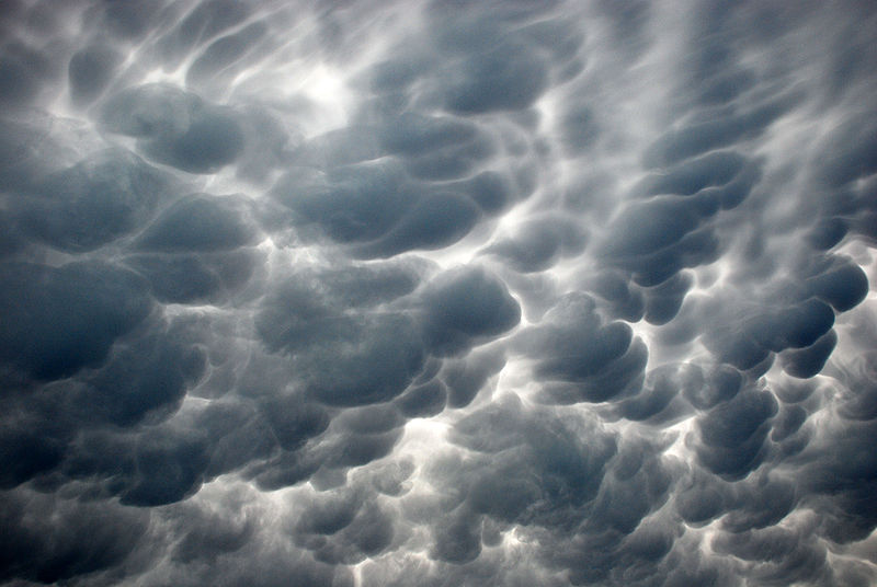
(Mammatus)
They can be single or plural-cellular, contain one or several convective cells:
They can generate tornadoes:
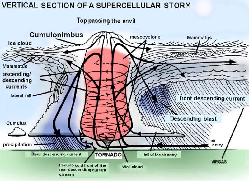
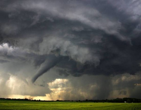
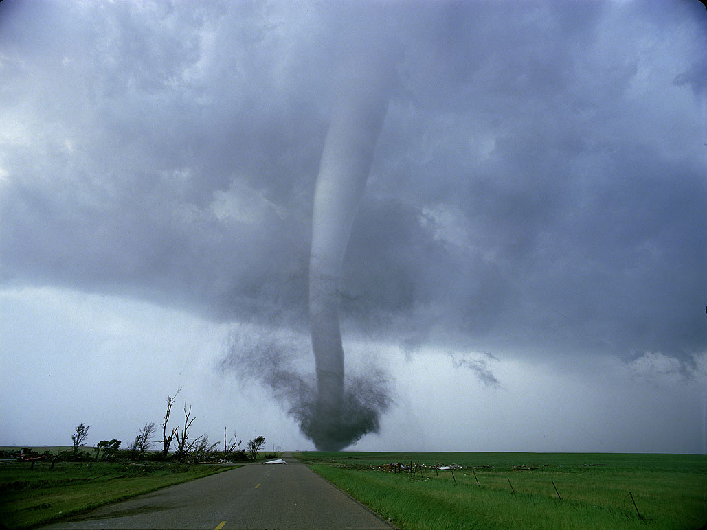
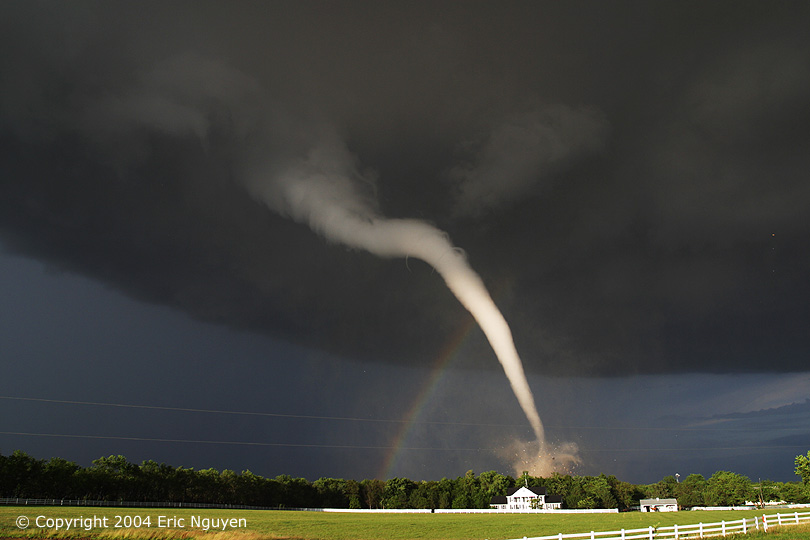
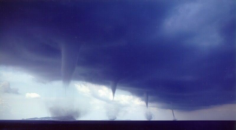
Cumulonimbus clouds are visible signs of the direct exchanges between the Tropopause and the ground.
They can even turn into larger systems such as cyclones, huge clusters of necessarily multicellular cumulonimbus which extends over hundreds of kilometers generating, up from the ground, circular winds with powers similar to or higher than the Jet Streams. As the cyclones size is considerable, they distort the Hadley or Ferrel cells in which they are. In addition, the Coriolis force amplifies winds when they go Eastward, and brakes it in the other direction. Thus, each cyclone has a half more dangerous than the other, the one where winds are going Eastward.
In the northern hemisphere, Coriolis forces, they turn in the opposite direction, clockwise.
Jet Streams amplify and direct them: The Tropopause icy air moving between 200 and 300 km/h rushes into the descending winds that cumulonimbus make (on their sides), they strengthen them which guide the whole structure, while, by the extra energy they bring, amplifying the damages on the ground. Thus, the jet streams are "rails" that disturbances, from the smallest cumulonimbus to the hurricanes, are forced to "follow" when they connect to them. Depressions that connect to them become avalanches of cold air, falling at high speed from the top of the Troposphere, over 10 km high, and crashing on the ground. The largest depressions deform a little bit the Jet Stream with which they are linked, but without destructing it: The rail from above remains the rail from above.
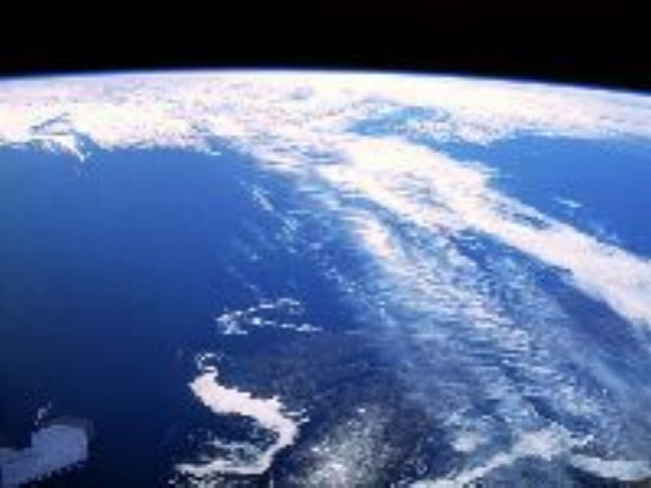
The Jet Stream above Canada: It pulls and drives the clouds along its path, almost straight East.
Depressions which are not connected to a Jet Stream are not avalanches of icy air though any ascending current induces air falls on its margins, just like the small counter-currents along rivers banks. They don't take in, or very few, the air of the upper Troposphere.
And all this, only within the first 15-20 kilometers which overlook us, of the 500 which define the Earth's atmosphere. It is 3% of its thickness, almost nothing.
Almost all Life on Earth is concentrated between a few meters below the ground and, at best, a few tens above (at worst, it is around a centimeter. For example on a parking). The most luxurious is in the most humid and less cold places. It is null in many places. I will not teach you anything, it's just to point out how this "huge" biosphere is thin and closely linked to all which surrounds it above and below, so much more fragile than the remainder. A thing that our "horizontality" too often pushes us to forget.
The ground is the bottom of the Troposphere, the Tropopause is its lid.
The land blocks down and heats the Troposphere. The Tropopause blocks up without heating. Random drawings that the Troposphere prints on the ground with depressions and anticyclones are a reflection of those it prints on the Tropopause. Just as it exists quiet areas on the ground, it exists on top too. These areas are quiet reservoirs, as are the Gyres in the oceans (cf, the previous sphere).
As for Gyres, volatile and gaseous human industry wastes will accumulate in these quiet areas, some "sixth continents above our heads", in short. As for Gyres, they stay there for long and the polluted region enlarges with time until its size is such big that the waste pushed to the margins are caught by the general circulation to be thrown elsewhere, including in the "descending icy air avalanches" that we saw.
If you understood how work the Hadley, Ferrel and Polar convective rolls described above, you see immediately where the greatest of these quiet areas are likely to be placed: The two poles.
The location and size of these "tropopausical gyres" are even easier to determine since the crisis of CFCs (Chlorofluorocarbons, first propellants of gas sprays, now banned worldwide) required the global attention to continuously monitor the Ozone layer disintegration since. The Tropopause Gyres actually focus on Ozone holes, and it is not surprising that it is primarily at the poles due to all foregoing above.
The first detected ozone hole is the one of the Antarctic:
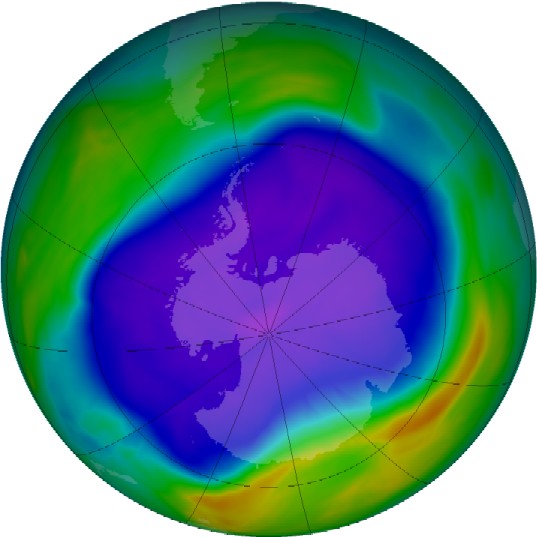
(NASA, September 24, 2006, at largest)
The second, very recently, is the one of the Arctic:
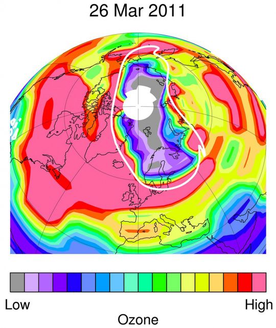
(NASA, March 26, 2011)
Thus, in addition to welcoming our Ozone depleting gaseous wastes - which widely opens the door to the deadly UV, thus accelerates the polar ices melting - these areas are also a receptacle for all our light effluents. The hard UV bombardment on it can only turn some into other molecules, simpler, and to be identified, but some of which will inevitably be highly toxic for Life..
At another level, and still on the toxic side, as all which can go up there goes up there, a part of the human radioactivity more or less accumulates there since the first atomic bomb aerial tests, and through Chernobyl and Fukushima.
As shown in the two NASA photos, the size of our "gaseous sixth continents" is now spilling polar cell boundaries. They are thus redistributed into the other cells and in Jet Streams. They regularly come down by the "icy avalanches" that we have seen and which can take place quite everywhere, in particular below Jet Streams.
About Fukushima, above the melting and exploding reactors, the March 15, 2011, the weather was as follows:
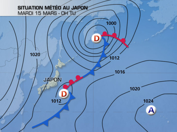
We had a very strong draft offshore Fukushima begging only to send the radioactive cloud directly below the Tropopause, which thus was done.
Ten days later, the situation did not change much:
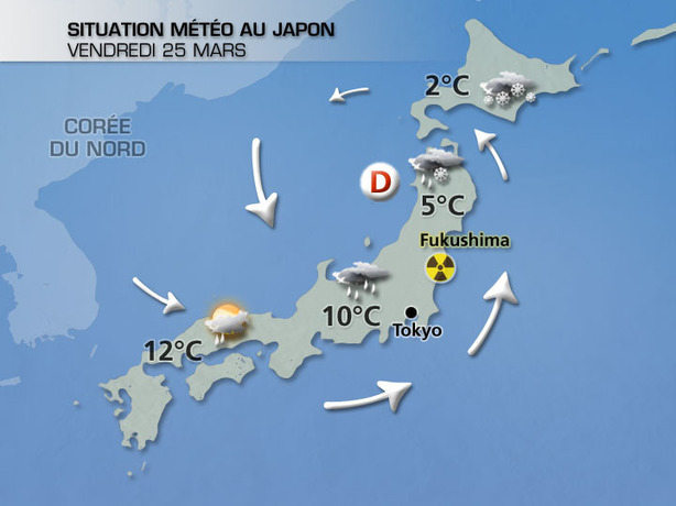
but at least it explains why in the Hokkaido Island and northern prefectures of Aomori, Iwate and Miyagi the Radiations level is now close to that of Fukushima in some places: The radioactive cloud was swept away by these winds and its fallouts watered its path.
So, a very large part of the Radioactive clouds leaked from the melting reactors went directly on top of the Ferrel cell. Then it followed its general trend, going northeastward, and was partly caught in Jet Streams. At this latitude, it went around the Earth in a few days, while spreading out each side:
![]()
The top image shows the situation as of March 20, 2011, the one below, a week later, on March 27, 2011.
Within a week, the Northern Hemisphere was already polluted, the main of the pollution having yet invaded the Ferrel cell and the Polar cell, from the Sahara to the North Pole.
Today, the two Hadley cells are necessarily contaminated too, and the Fukushima radioactivity, although concentrated in the Northern Hemisphere, is now certainly distributed throughout the Southern Hemisphere to the South Pole. For which remained "stuck to the ceiling," like for CFCs and other Ozone-depleting, it gradually joins the two Polar Gyres, sometimes descending through icy avalanches which appears where the ground surface is so hot that the lifts it causes are the fastest, drag down the ceiling cold air.
In fact, the sudden increase of radioactivity on the ground caused by these avalanches has been observed several times in the USA during the intense heat they traversed from the beginning of the 2012 summer, due to that intense heat generates large and powerful ascending currents.
Whereas, as in the Pacific Ocean where Tepco, the company that owns the Fukushima Dai-ichi crippled reactors, continues to dump every day hundreds of liters of radioactive waters, every day and still today, radioactive gasses escape from their melted reactors buildings and disperse along with winds, the Troposphere general radioactive level continues to increase.
It increases anyway apart from Fukushima because of all plants, minings, "reprocessing", radioactive wastes, "storage", and military centers, and nuclear smugglings sow the world every day too.
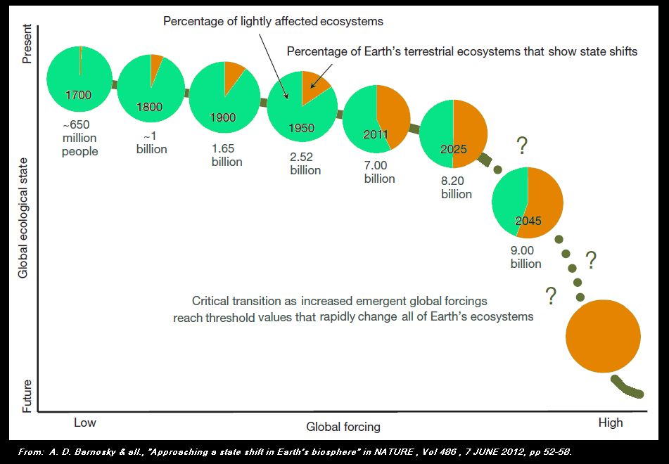
I don't know how fast all this pollution, the radioactive along with the others, increase every day, but the overall situation does not seem to remain viable for centuries. It is very possible that a major crisis will happen soon to splash in front of our eyes: The Tropopause is not increasing in size while the human population still follows its exponential trend, and the damages induced by humanity follow this same trend:
I think it would be better not to be there when everything will boil in the Tropopause.
***** Mahina, July 30, 2012 *****
Addendum of November 11, 2012:
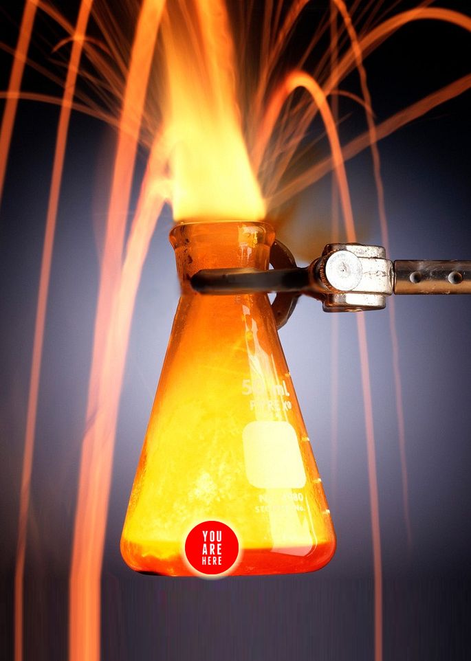
I just got this image that perfectly summarizes the situation for me:
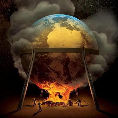
Like some algae saturating a small puddle up to die, suffocated by their own competition in this limited resource and by their own wastes, life will continue as it may when the last human will
Like some algae saturating a small puddle up to die, suffocated by their own competition in this limited resource and by their own wastes, life will continue as it may when the last human will be dead of the consequences of the lack of general environment reasoned management from his peers.
There is and there will always be at best only one Biosphere on Earth.
Finally, and despite the invention of an extraordinary stand back on what we live by, we have no more real intelligence that the algae of in this example.
I don't know if there will still be humans in 2100.