By Mimi Mato, Tuesday, July 10, 2012, 12:48 pm for the original French version.
English fixed by Pimprenelle Xwzq, Sol hog, and Marguerite Dehler.
I presented the first sphere, the solid one in the previous chapter..
In this chapter, I would like to look into the second sphere, the liquid one, which "covers two thirds of the entire planet," which is why there is life on this round stone which in an infinite void, rotates around a permanent nuclear explosion which without this water would never have sheltered anything.
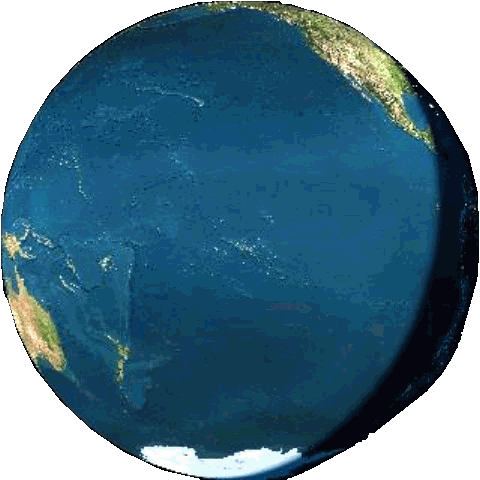
Here it is, seen from above my home this time, for a change:
It's wet, eh?
But what does "wet" mean?
Let's step back a bit: What is "all this water which covers two-thirds of the planet"?
Well, not so much, indeed, if we look at it a bit differently:
To start, lets remove it.
And we get this, a map of the ocean floor, an image now rather well known and quite reassuring by the use of colours to depict the surface of our one and unique world:
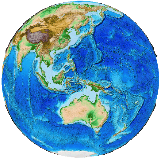
We guess then that there was not that much, but while further looking at the ocean floor as if it was a virgin territory soon available for our exponential population growth, we are apt to forget to ask about what the virtually removed part represents. Thus, here is all the water on Earth, relative to Earth:
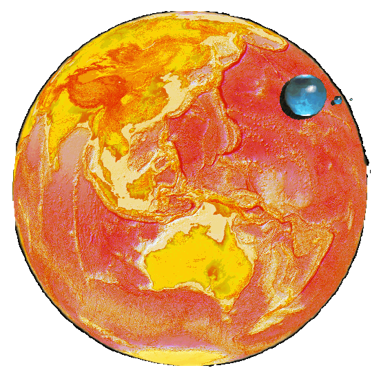
The colours are changed because it is a bit like that, darker without doubt, that our Earth would be if all the water was strolling somewhere in space as I suggest here:
Do you see the size of these virtual satellites which, in comparison, might be less than the size of, take the "huge" Australia only?
Pathetic, isn't it?
All the drinking water would not cover even the "small" landmass known as Japan!
.
The consequence is that any significant soluble pollution is quite immediately global, and has an immediate impact on all life on Earth. Evidence can be calculated by the estimated-measure of the thickness of the oil layer which covers all the world's oceans, which thickness, if memory serves me right, was estimated to be about 1 micron -- about thirty years ago (hard to find my source, perhaps in the Ramade: 1982, François Ramade, "Elements of Applied Ecology", McGraw-Hill, 452pp.), certainly thicker today and its impact on the water-air respiratory exchanges can only have increased. Thus, I let you estimate what our wastes into rivers may lead as results, for instance, chemical or radioactive wastes.
The Earth rotates at least since Galileo.
If the plates that form the Earth's crust move at a speed generally around -or below- 5 cm per year, water is much more unstable, as you know.
Oceans are a bit like water in a pan that contains a few eggs emerging slightly above the water surface. The water moves all the time, everywhere, in an uneven and changing manner, similar to the movements in this pan.

Like in this pan, there are "mainstreams" made by most of this water. They run throughout the wet sphere along the easiest routes at each moment. If the Earth's crust is indeed made up of elements of different densities, surfaces and weights, it is the same in water as it expands with heat.
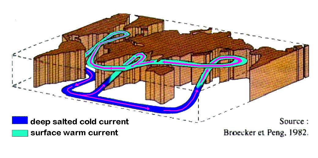
This is a key point: Hot water "floats" on cold water almost as typically as oil (oil of rock as well) on water. So, not only there are surface currents and counter-currents, so to speak, trying to maintain the horizon on the horizon, but there are also bottom currents and counter-currents, and between the bottom and surface currents and counter-currents.
As well, if surface waters have a temperature ranking roughly between 1 and 32 °C, depending on latitude and season, the ocean floor is very homogeneous at around 4-5 °C, just because the sun rays never reach there and that cold water is heavier than when hot.
So, why is there no ocean at more than 32°C?
After all, one could imagine that the sun could heat more in some spots.
There is none because as soon as the 31°C is reached on a "large" surface, in a certain manner, the air does not bears it, and induce hurricanes whose major effect is to pump and disperse this heat into the colder upper atmosphere: The hot water heats the air which itself is more unstable (more below) and thus it expands, loses density, seeks to "float "above the colder air that surrounds and covers it, thus goes up, all the more quickly as variations are important between its temperature and that of which surrounds it, like a column of bubbles in a lemonade glass (or of champagne, according to your social environment ...).
When it is intense, a hurricane naturally takes shape.
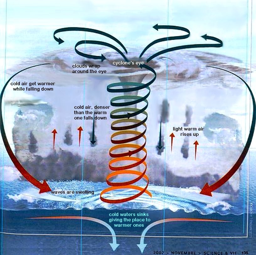
Therefore, Ocean water temperature varies at the surface, a bit, between 1 and 31° with localized peaks at 0°, up to 32°, perhaps 33, or even 34, but never on a wide area, and it remains at about 4°C at the "deep" bottom. Continents nevertheless limit the tendency imposed by the rotation of the Earth so that the currents are directed all West to East (since the crust below, turns from East to West). The only place where the continents allow, by their absence, water to flow all around the Earth is in the Antarctic, around the South Pole.
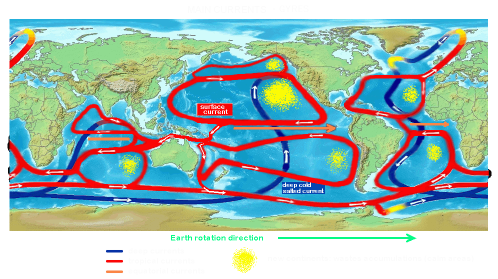
This illustration shows the dominant currents flow:
It can greatly vary depending on time, seasons, which invariably boosts surface currents concurrent with both the earth's rotation and the sun's heat, while continents, of course, are constantly 'barriers'.
The advantage of this knowledge is, of course, to be able to anticipate how our pollution spreads into the Aquatic Sphere.
At the South Pole, it's pretty simple as we have seen:
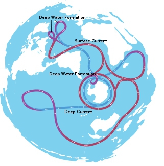
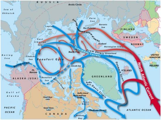
However, the Northern Pole is much more complex because of the continents' masses, and, unlike the South Pole, there can't be stable mainstreams:
At the general level, there is an "atomized" circular organization, bounded by continents and the earth's rotation speed: All rotates in 24 hours, at the poles by a few kilometers to about 32 000 km at the equator. The speed, which decreases from the Equator to the poles, roughly imposes symmetrical currents on each side of the Equator, relative to the continents, latitudes, and, for surface water only, the seasons:
Equatorial currents are, of course, the fastest and warmest ones, but they may temporarily disappear some years (e.g. El Niño periods). Everything moves very slightly, depending on seasons.
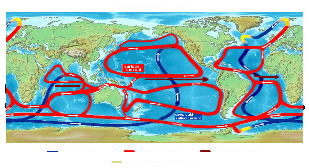
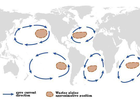
We know that surface currents tend to organize themselves into six whirling cells more or less interconnected (the South Pacific one being the least connected one). These six cells are now known, and named "Gyres."
Their centers are obviously quieter, almost calm. They tend to draw with them all that floats and drifts randomly around and elsewhere. The North Pacific Gyre, the largest on Earth, circulating from Japan to the USA, is the most polluted one - known as the Great Pacific Garbage Patch - while the others are also polluted, at a lesser but still substantial degree:
And, simplified:
The tsunami of March 11, 2011 did not help, nor the still on-going Fukushima disaster (endless because the salt water which is - still to this day - used to cool the crippled reactors -- is still taken from, then returned into the ocean in a radioactive state).
Add to this another dispersion factor, biological and alive: The marine flora and fauna, which generally follow the mainstreams, yet have their own independent routes, notably North-South migratory species (whales, etc..).
So, now you've got so an idea on how pollution is gradually spreading across and down to the bottom throughout the entire wet sphere, from worst to least polluted, from the Pacific to the Indian Ocean and the Atlantic one, and inversely. Thus you see how Fukushima, and chemical pollutions are found in our glasses and on our plates results of our plundering of the sea. Tuna caught offshore America are now more radioactive than ever, as shown by U.S. researchers as recently as a few weeks ago. It is obvious that nothing happens only to others, marine pollution is democratically distributed globally even though it takes longer than air pollution to share its impacts.
On November 1, 2011, the first radioactive waters were detected at 3,500 km away from Japan, due East, into the mainstream:
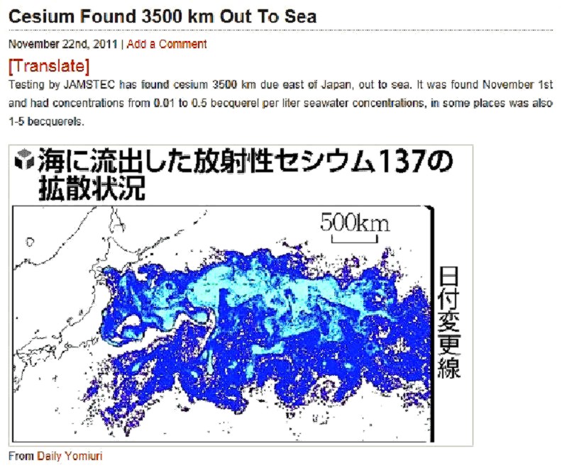
It was eight months after the disaster, almost 15 months now, double time later. There are 8,200 miles between Japan and the USA. The North Pacific Gyre will retain a large part, Hawaii will become more radioactive, and the remainder will head either to Alaska or along the Equator to Australia and the Atlantic. Let's recall that since March 2011, radioactive water used to cool the 4 crippled reactors is put back into the ocean, on a daily basis. That pollution is still continuous, substantial and severe.
And now, meal time.